


ST. PETERSBURG, Fla. — Four tornadoes reportedly touched down in Bay area counties Friday afternoon as a line of intense storms moved swiftly through the area and across the state.
What's believed to be an EF-1 tornado touched down Friday afternoon in New Port Richey, part of a long line of storms that ripped off roofs, downed trees and left thousands without power.
The National Weather Service said seven homes in the 3400 block of Player Drive were damaged. That's located in the Fairway Springs subdivision.
Tornadoes were also confirmed in Spring Hill in Hernando County, Seminole in Pinellas County, and Land O'Lakes in Pasco County. Damage was reported at homes in Larendale Circle. About seventeen homes had roof damage.
In Seminole, plans were under way to open at least two shelters for residents affected by storm damage to their homes.
A total of 14 tornando warnings were issued Friday afternoon.
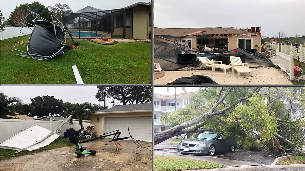
PHOTO GALLERY: Fast-Moving Storm Damages Parts of Pinellas, Hillsborough Counties
As of 9 45 p.m., 8,838 TECO customers are without power. | Check outage map
Just over 3,400 Duke Energy customers do not currently have power, as well. About 2,500 of those are in Pinellas County, 63 are in Polk, 974 are in Pasco; and about just over 51 in Hernando. | Check outage map
As of 9:45 p.m. 164 FPL customers in Manatee County and 35 customers in Sarasota County are also without power.
Central Florida effects
As the line of storms made its way east, residents in Lake County felt its effects, as well. High winds blew trees down, which in turn took out power lines.
One of those downed power lines sparked a fire at the intersection of Buckhill road at Howey Cross Road near Clermont.
A homeowner we spoke to said he could only watch as trees and limbs came crashing down in his front yard, causing damage to his home.
"i was watching it through the window and the door and saw it coming down," said Umadat Persaud. "But you just have to watch it and let it go."
The downed power lines left some Lake County residents without power for several hours.
You can view some of our time-stamped updates below.
7:30 p.m. update: The American Red Cross is directing anyone in need of shelter this evening following the severe weather to go to Christ Lutheran Church in St. Petersburg.
5:10 p.m. update: We've received several storm damage reports in Pinellas Park.
5:04 p.m. update: There are reports of about seven homes damaged in New Port Richey near Main Street.
4:51 p.m. update: Deputies have blocked off area around Conrad Mobile Home Park in Pinellas County. Concerns about power lines down and across trees.
4:46 p.m. update: All storm warnings have expired. Still a lot of rain/thunderstorms in eastern sections of Polk County, but that is winding down and moving into Osceola County.
PHOTO GALLERY: Fast-Moving Storm Damages Parts of Pinellas, Hillsborough Counties
4:38 p.m. update: Spectrum Bay News 9's Saundra Weathers in St. Petersburg, home damaged off MLK and 16th Street. Roof peeled back. ... Reports of lightning strikes in Tampa, fire crews responding.
4:33 p.m. update: Power lines down at Conrad Mobile Home Park in Pinellas County. One mobile home crushed by tree. No serious injuries reported, one woman was treated and checked out.
4:33 p.m. update: 35000 TECO customers without power, 14000 Duke Energy customers without.
4:30 p.m. update: All of the tornado warnings have been cancelled.
4:27 p.m. update: Conrad Mobile Home Park in Pinellas County, extensive damage. Fallen branches, roofs crushed by trees.
4:25 p.m. update: Watching the Auburndale area very closely. Winds moving at about 40 p.m. Residents in that area should take cover.
PHOTO GALLERY: Fast-Moving Storm Damages Parts of Pinellas, Hillsborough Counties
4:20 p.m. update: Polk County under Tornado Warning for 10 more minutes.
4:17 p.m. update: Tweet from Pinellas County Sheriff's Office: Initial report that one person with minor injury as result of storm damage northwest of Starkey Rd & Park Blvd in Seminole. City and Pinellas County Public Works clearing roadway. PLEASE AVOID THE AREA.
4:16 p.m. update: Damage at Park and 91st in Pinellas County
- WEATHER ON THE GO: Download the Spectrum Bay News 9 app and get Klystron 9 alerts wherever you are.
- GET WEATHER ALERTS: Sign up to receive weather text alerts from Spectrum Bay News 9
- Klystron 9 | 7-Day forecast | Tampa Bay-area temperatures | Travel weather
4:13 p.m. update: Strong winds in Central Polk County. Mobile homes venerable.
Hernando County tornado warning dropped; Manatee County tornado warning dropped
4:12 p.m. update: Withlacoochee Electric: 10,948 without power in Pasco, Hernando and Citrus. 17,333 Duke Energy customers without power. | Check outages map from Duke Energy
4:11 p.m. update: 37000 TECO customers without power. | Check outages map from TECO
4:10 p.m. update: Possible tornado spinning up in Lakeland Highlands. Residents in that area should take cover.
4:06 p.m. update: Tornado Warning in Polk County until 4:30 p.m.
4:02 p.m. update: Damage at Holiday Village Mobile Park in Seminole. Three trailers damaged, power outages in the area also.
4 p.m. update: Tornado Warning in Hernando, Pasco, Manatee
Get latest county-by-county warnings here
3:51 p.m. update: Hernando County Sheriff's Office says: Severe weather is being reported in Spring Hill. Dunkirk, Oakridge, Lorendale. Trees down and roofs blowing off.
Please seek shelter.
Get latest county-by-county warnings here
3:50 p.m. update: Polk County now under Tornado Warning.
3:46 p.m. update: Carport destroyed in Clearwater area, among the damage reports we've received
New tornado warning in Eastern Pasco County around St. Leo, moving very quickly
3:44 p.m. update: Get latest county-by-county warnings here
3:41 p.m. update: Withlacoochee River Electric reports 6101 outages in Pasco County.
More than 14,000 Duke Energy customers without power. Check outages map from Duke Energy
3:40 p.m. update: 26000 TECO customers without power. | Check outages map from TECO
3:37 p.m. update: Still three tornado warnings in effect.
Get latest county-by-county warnings here
3:34 p.m. update: Damage reported around Park Boulevard / Starkey Road in Pinellas Park in central Pinellas County.
3:30 p.m. update: 11,200 TECO customers without power. Withlacoochee River Electric reports 1919 outages in Pasco County.
Get latest county-by-county warnings here
3:26 p.m. update: Tree down in north Redington Beach, among other areas where damage has been reported.
3:23 p.m. Storm approaching Manatee County. Area of most concern is around downtown Tampa Bay, according to Mike Clay.
New tornado warning in effect until 4 p.m. in area of Temple Terrace, USF, Seminiole Heights.
Storm approaching Palma Ceia area
3:20 p.m update: Tornado warnings in parts of Pinellas, Pasco, Hillsborough. There are 5 warnings in total.
Get latest county-by-county warnings here
3:14 p.m. update: Reports of strong winds with damage along the Park Blvd corridor from Seminole into Pinellas Park.
New warning for parts of Pasco County until 3:45 p.m. ... located near Jasmine Estates moving about 30 mph
3:12 p.m. update: Gusty winds in the Carillon area of northern Pinellas County.
3:11 p.m. update: Northern Pinellas Tornado Warning about to expire.
3:06 p.m. Tornado warning in Citrus County until 3:30 p.m. and Central Pinellas for 3:30 p.m.
The Central Pinellas storm system was moving quickly at 3:09 p.m. The system is headed toward Gandy and Pinellas Park. Residents in those areas should seek shelter.
3:01 p.m. update: Tornado Warning for Pinellas County until 3:15 p.m.
45 to 50 mph winds in parts of Pinellas County, according to Spectrum Bay News 9 Chief Meteorologist Mike Clay.
They system is moving through quickly. At 3:03 p.m. a strong line of storms was over Safety Harbor.
Central and southern portions of Pinellas counties remained under a severe thunderstorm warning at 3:03 p.m.
PREVIOUS
A line of showers and thunderstorms will move through our area late this afternoon and this evening. A few thunderstorms could be strong with gusty winds and heavy downpours.
The rain will move east across the area then move out tonight with drier air moving in behind the cold front.
- Rain and thunderstorms through evening
- Cooler and drier Saturday
- Rain returns Sunday
High pressure builds in behind the front and it will be breezy and cooler tonight.
Low temperatures will be in the mid 50s in our northern counties and the low to mid 60s in Tampa Bay.
Saturday will be drier and breezy with highs in the mid 70s. Some clouds will linger as the moisture won’t be pushed very far south.
- WEATHER ON THE GO: Download the Spectrum Bay News 9 app and get Klystron 9 alerts wherever you are.
- GET WEATHER ALERTS: Sign up to receive weather text alerts from Spectrum Bay News 9
- Klystron 9 | 7-Day forecast | Tampa Bay-area temperatures | Travel weather
By Sunday, the stalled front to our south will lift north as a warm front. Rain chances will move back into our area.
Sunday's rain chance is 60 percent.
Warmer and more humid condition will return on Sunday and continue into next week. Rain chances remain at 60 percent for Monday and Tuesday.
7-day forecast

We want your pictures!
Show us what the weather looks like in your neighborhood. Your photo could end up on Spectrum Bay News 9.
- Get the Spectrum Bay News 9 app for iOS or Android
- Tap "Submit Content" at the bottom of the app menu
- Remember to include your name and location