


ST. PETERSBURG, Fla. — Hurricane Dorian continues to show some signs of weakening as it continues to linger just north of Grand Bahama Island. It is still expected to deliver rain and hurricane force winds to the island into Tuesday morning.
- DORIAN LATEST:
- LIVE UPDATES:
- TRACK IT: Get tropical updates, forecast models, satellite loops, and more
- POWER OUTAGES: Interactive maps and phone numbers
- CLOSURES: School, business, facility closures and cancellations
- SAND BAGS: Where to find sand bags in the Bay area
- LIVE WEATHER CAMERAS: Sky 9 live cameras
- WEATHER BLOG: Defining, Understanding the "Cone"
- STORM SEASON 2019: Latest headlines | Biggest hurricane myths debunked | Interactive storm tracker | Printable supply checklist | Tropical storm 2019 names
- FREE WIFI HOTSPOTS: Charter Communications has opened up more than 32,000 Spectrum WiFi hotspots in Florida, making them available to all to help in preparation for Hurricane Dorian. Visit this link at Spectrum.com for more information on the exact location of those Spectrum Hotspots in Spectrum service areas across Florida. To connect, look for the Spectrum WiFi Network under your device’s WiFi settings. Charter Communications is the parent company of Spectrum Bay News 9.
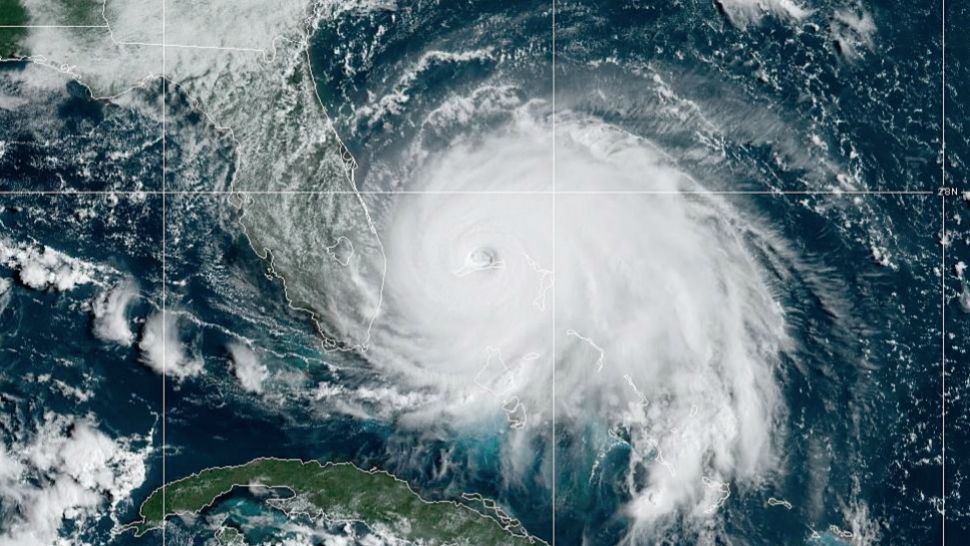
As of the latest forecast, Dorian is now about 25 miles northeast of Freeport, Grand Bahama and about 105 miles off West Palm Beach. It had just started to make a slight west-northwesterly turn.
Maximum sustained winds were at 125 mph with higher gusts.
The core of extremely dangerous Hurricane Dorian will continue to pound Grand Bahama Island through much of today and tonight.
The hurricane will move dangerously close to Florida’s east coast tonight through Wednesday night.
A Storm Surge Warning is in effect for
- Lantana to Savannah River
A Storm Surge Watch is in effect for
- North of Deerfield Beach to south of Lantana
- Altamaha Sound to South Santee River
A Hurricane Warning is in effect for
- Grand Bahama and the Abacos Islands in the northwestern Bahamas
- Jupiter Inlet to Ponte Vedra Beach
A Hurricane Watch is in effect for
- North of Deerfield Beach to Jupiter Inlet
- North of Ponte Vedra Beach to South Santee River
A Tropical Storm Warning is in effect for
- North of Deerfield Beach to Jupiter Inlet
A Tropical Storm Watch is in effect for
- North of Golden Beach to Deerfield Beach
- Lake Okeechobee

Dorian has been stationary much of the day. The reason the cyclone has moved very little is because it is caught in weak steering currents between high pressure ridges to its east and northwest and a trough to its north.
This weak flow should result in a very slow and likely erratic northwest drift through at least early Tuesday. After that time, the models are in general agreement that the ridge to the east and trough to the north will amplify.
This change in the steering pattern should cause Dorian to move a little faster to the north on Wednesday and to the northeast on Thursday and Friday.
The stall or very slow movement over the last 24 hours will begin to end as Dorian will feel the influence of the weakness in the area of high pressure combined with the trough moving across the Eastern United States. This will finally allow Dorian to move northward.
There is still some minor uncertainty as to how far west with Dorian’s current NW movement the hurricane can get before taking on a more northerly move by later Tuesday. As it feels the influence of the trough, wind shear will increase so Dorian is expected to weaken somewhat.
This wind shear, combined with its northerly movement, will keep the strongest wind on the east side of the center. With the center likely to stay offshore, the winds on the west side of the hurricane will be over the Eastern part of Florida from overnight tonight through Tuesday and into Wednesday morning.
Right now it looks like widespread tropical storm force winds (39-73 mph) will be felt on the East Coast with some isolated Hurricane Force winds (74+) The highest wind threat will be where the land juts out a bit around Cape Canaveral, for example.

For The Tampa Bay Area, we are just expecting some gusty showers on Tuesday. Some wind gusts, especially farther east in Polk County, may reach 40 mph, but most areas should remain below tropical storm force.
The east coast will also experience some storm surge as Dorian parallels the coast. The storm surge will be found in areas along the coast while the east or northeast wind is occurring.
Once Dorian passes those locations the wind will shift to offshore quickly, allowing the water to recede. The worst of it would be between 4-7 feet.
Following Dorian’s move northward to the east of Florida, it will continue to be picked up by the trough and accelerate NE along the SC/NC coast before heading out into the Atlantic later in the week.