


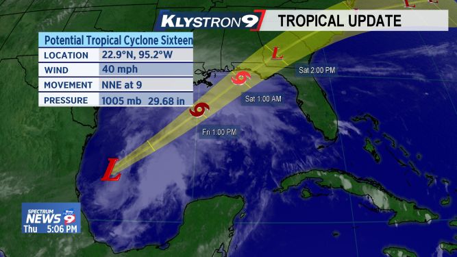
ST. PETERSBURG, Fla. — The disturbance over the southwestern Gulf of Mexico is now moving north-northeastward with gale-force winds.
- Track the Tropics on Spectrum Bay News 9
- Storm Season 2019 headlines, preparation tips
- WATCH: Tropical updates each hour at :49; Download Spectrum TV app
It's expected to develop into a tropical or subtropical storm early Friday.
Remember this will be a lopsided, poorly organized system with most of the significant weather east of the center.
There could be a risk of tornadoes in Florida late Friday night and into Saturday.
This will be a fast moving system so flooding from rainfall shouldn’t be a big problem.
- WEATHER ON THE GO: Download the Spectrum Bay News 9 app and get Klystron 9 alerts wherever you are
- GET WEATHER ALERTS: Sign up to receive weather text alerts from Spectrum Bay News 9
- Klystron 9 | 7-Day forecast | Tampa Bay-area temperatures | Travel weather
SUMMARY OF WATCHES AND WARNINGS IN EFFECT:
A Tropical Storm Warning is in effect for...
* Mississippi/Alabama border to Yankeetown Florida
* Grand Isle Louisiana to the Mouth of the Pearl River
A Storm Surge Warning is in effect for...
* Indian Pass Florida to Clearwater Beach Florida
SUMMARY OF 500 PM INFORMATION
LOCATION...24.1N 93.7W
ABOUT 445 MI...720 KM SW OF THE MOUTH OF THE MISSISSIPPI RIVER
MAXIMUM SUSTAINED WINDS...40 MPH...65 KM/H
PRESENT MOVEMENT...NE OR 45 DEGREES AT 12 MPH...19 KM/H
MINIMUM CENTRAL PRESSURE...1004 MB...29.65 INCHES