


ST. PETERSBURG, Fla. — Regardless if the low becomes a tropical storm or not, our forecast will not change.
- Track the Tropics on Spectrum Bay News 9
- Storm Season 2019 headlines, preparation tips
- WATCH: Tropical updates each hour at :49; Download Spectrum TV app
- Stay connected to us wherever you are! With text alerts, get breaking severe weather and storm updates along with other area information sent to you as a text message to your wireless device
This disturbance will result in rounds of rain for the area, heavy at times. Parts of the state, especially the Panhandle will receive gusty winds but that is not the main threat with this storm.
The low level center is well displaced from the significant weather to the east.
Tropical storm force winds extend 175 miles east of the center. Although the center is evident, it is still elongated and not totally closed so this remains a Potential Tropical Cyclone at this time.
The motion is a somewhat uncertain given the lack of a well-defined center. The track model guidance remains in good agreement on the system moving quickly northeastward toward the northeastern Gulf Coast during the next 24 hours as it interacts with the upper trough.
The center of the storm doesn't matter as the wettest weather will be displaced well east of the center.
Our main impacts will be:
1) The potential for tornadoes tonight – Saturday morning
2) Above average tide levels with a storm surge of 1 to 3 feet likely and some isolated spots 3 to 5 feet above normal, especially along the Nature Coast.
3) Storm is fast moving so flooding is not expected. It is more beneficial rain than anything, especially over north Florida and Georgia.
This storm will move quickly so flooding is not likely. The good news is a majority of the region will get beneficial rains as it passes.
Regardless of the exact evolution of the system, portions of the northeastern coast of the Gulf of Mexico will experience strong winds, locally heavy rains, and storm surge later today and Saturday.
A few tornadoes are possible.
Conditions should improve by midday Saturday as the low moves away from Florida and up the East Coast of the U.S.

SUMMARY OF WATCHES AND WARNINGS IN EFFECT:
NOAA HURRICANE HUNTER AIRCRAFT FINDS THE SYSTEM STRONGER.
STORM SURGE AND TROPICAL STORM FORCE WINDS EXPECTED ALONG PORTIONS OF THE FLORIDA GULF COAST LATER TODAY AND TONIGHT.
STORM SURGE WARNING CONTINUES FOR PINELLAS, PASCO, HERNANDO, AND CITRUS COUNTIES IN OUR VIEWING AREA.
SUMMARY OF 11:00 AM INFORMATION
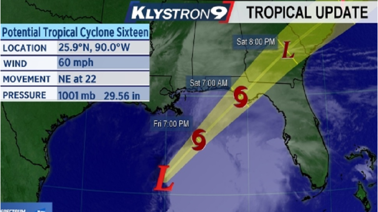
LOCATION...25.9N 90.0W
ABOUT 230 MI SSW OF THE MOUTH OF THE MISSISSIPPI RIVER
ABOUT 395 MI SW OF PANAMA CITY FLORIDA
MAXIMUM SUSTAINED WINDS...60 MPH
PRESENT MOVEMENT...NE AT 22 MPH
MINIMUM CENTRAL PRESSURE...1001 MB...29.56 INCHES