


We're just over two months into the 2020 Atlantic hurricane season, and records are already falling.
With less than a month until the statistical peak of hurricane season, the Atlantic basin has churned up 11 named storms, the most so early in a season.
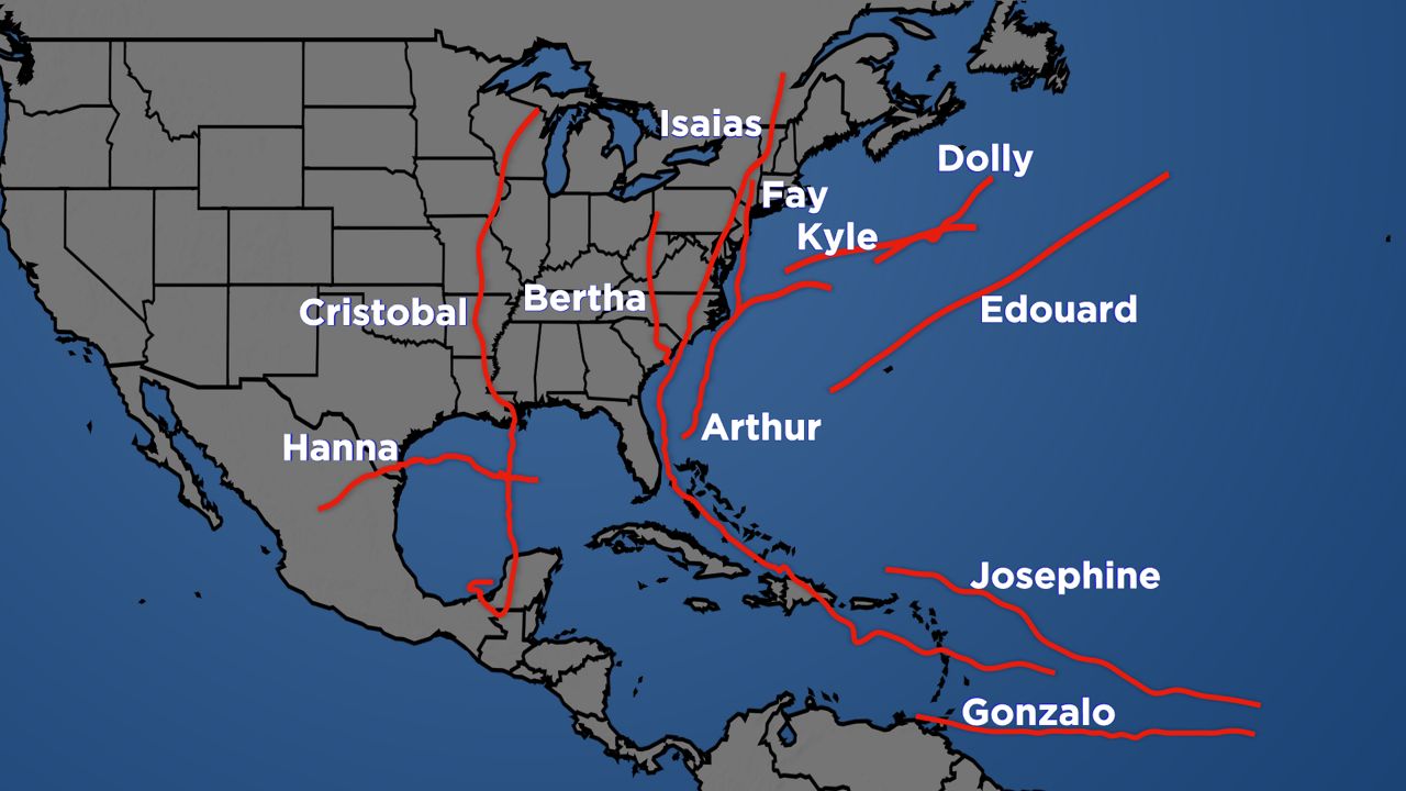
With so many to keep track of, let’s recount some of the most memorable ones.
Several hours after a depression formed off the Space Coast of Florida, Arthur was named a tropical storm on May 16. This marked the sixth consecutive season with a named tropical cyclone before the official start of hurricane season, which is June 1.
Tropical storm warnings were issued for the Outer Banks of North Carolina as Arthur headed north.
While never making an official landfall, passing just miles west of Cape Hatteras, the storm brought heavy rain to much of the Southeast. Dozens of people needed to be rescued along the coast due to the rip currents Arthur generated.
Continuing the early start to the season, Tropical Storm Bertha formed on May 27th off the Southeast coast. This marked just the third time on record that two named storms were recorded during the month of May.
One of the shortest duration tropical cyclones, Bertha made landfall just east of Charleston, South Carolina a mere one hour after being named.
Still, with winds of 50 mph and rainfall from the developing disturbance that would become Bertha, the storm racked up over $200 million in damages.

The origins of Cristobal stem from a remnant low of what was Tropical Storm Amanda in the Eastern Pacific. This area of low pressure crossed Central America before emerging in the Bay of Campeche.
Reforming into a tropical storm, Cristobal became the earliest third-named storm when it was named on June 5th. Two days later, after heading north over the Gulf of Mexico, the storm made landfall near Grand Isle, LA as a tropical storm with 50 mph winds.
While rainfall did cause flooding in parts of the South, continuing north, Cristobal went on to become just the fourth tropical cyclone to reach the state of Wisconsin, and the first in over 30 years.
A derecho spawned by Cristobal over the Great Lakes region knocked out power more than half a million as powerful winds from the a line of thunderstorms blasted through. A derecho is a strong wind storm associated with a line of showers or thunderstorms.

A quick-hitter, Fay developed over the warm waters of the Gulf Stream, just east of the Outer Banks of North Carolina.
Heading north, tropical storm alerts were issued along the Northeast from Delaware to Rhode Island. With winds of 50 mph, Fay made landfall near Atlantic City, NJ on July 10th, the first tropical cyclone to make landfall in New Jersey since Tropical Storm Irene in 2011.
Rainfall from Fay led to some road closures, including I-76 outside Philadelphia. Several swimmers lost their lives from Fay’s rough seas.
Fay racked up over $400 million in damages and was indirectly responsible for five fatalities.

Taking advantage of warm waters, a disturbance moving through the Gulf of Mexico organized enough to become Tropical Storm Hanna on July 23rd. With just a couple of days before the cyclone would reach land, Hanna was expected to make landfall along the Texas coast as a moderately strong tropical storm.
Defying the forecast, Hanna intensified on July 25th to become the first hurricane of the season. The storm continued to intensify right up until landfall with an eye becoming apparent on satellite imagery.
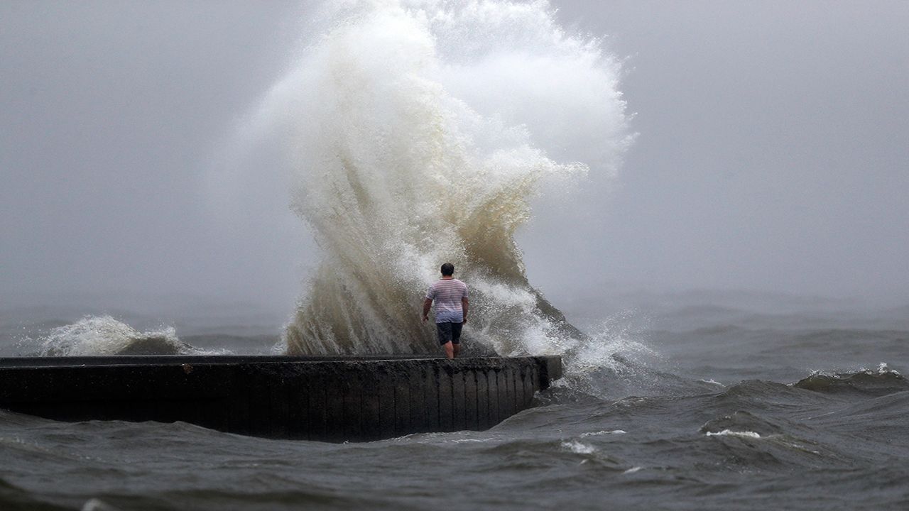
Later that day, Hanna made landfall as Category 1 storm with winds of 90 mph at Padre Island, Texas, about 30 miles south of Corpus Christi.
Damage from storm surge and high wind caused the Bob Hall Pier in Corpus Christi to collapse. Rainfall over a foot in some spots of far South Texas led to flooding and water rescues.
Hanna eventually dissipated as it moved inland over the rugged terrain of Mexico.

Originating as a tropical wave that came off the coast of Africa, the large circulation of what would become Isaias took its time in organizing.
On July 29th, Isaias finally formed as a tropical storm south of Puerto Rico in the Caribbean Sea. Becoming the season's second hurricane a day later, the storm passed over the Bahamas before encountering hostile conditions that caused it to weaken back to a tropical storm. Isaias scraped the east coast of Florida with tropical storm conditions on August 2nd.
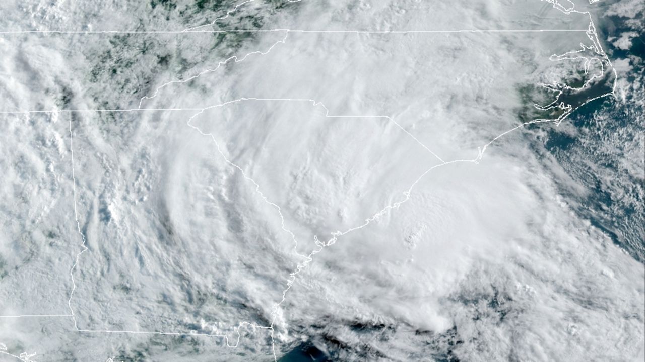
From there, Isaias traveled north, intensifying back into a hurricane. Hurricane and tropical storm alerts were posted from South Carolina all the way to Maine.
Late on August 3rd, Isaias made landfall as a Category 1 hurricane with winds of 85 mph at Ocean Isle Beach in North Carolina, about 30 miles northeast of Myrtle Beach South Carolina.
Strong winds and storm surge damaged homes in nearby Oak Island, NC. Two people lost their lives from an EF3 tornado spawned by Isaias, the strongest tornado from a tropical cyclone in 15 years.
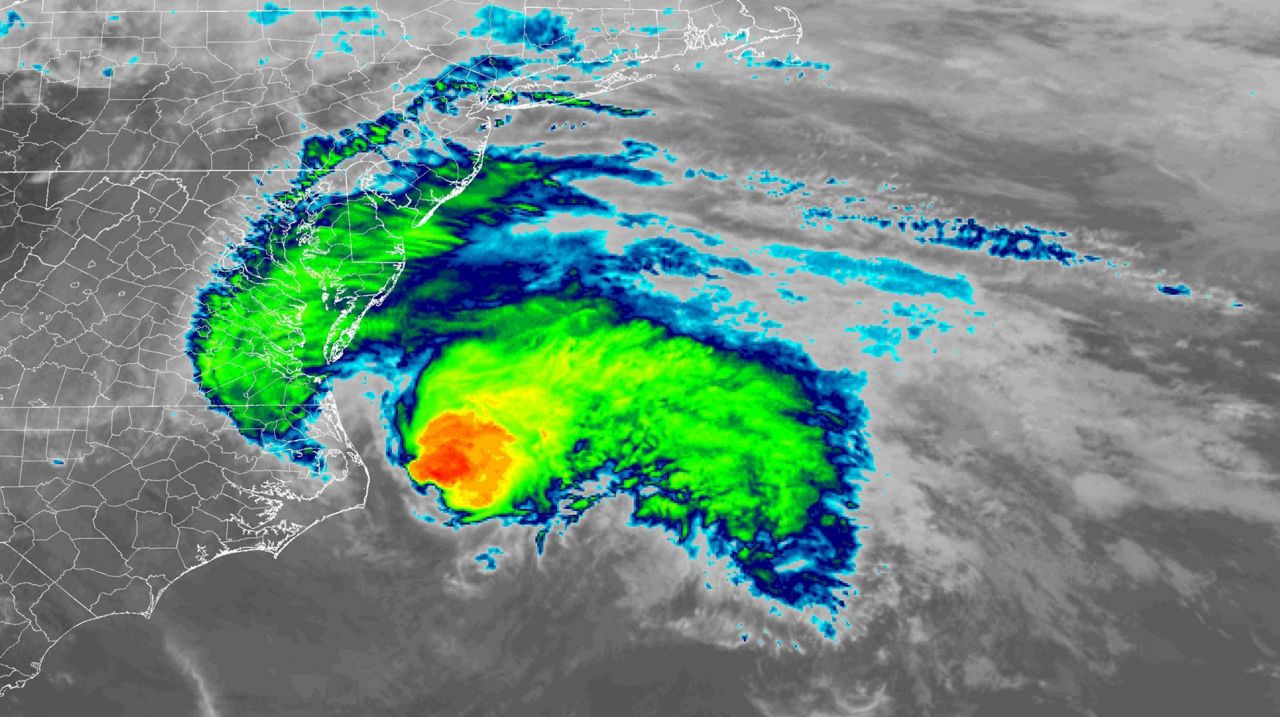
As Isaias accelerated north, impacts spread to the Mid-Atlantic and Northeast.
Isaias was the most impactful wind event in New York City since Sandy struck in 2012. Winds gusted to 78 mph in the city and knocked out power to millions across the Northeast.
The storm continued into Canada before finally meeting its demise.
If the first two months of the season was a sign of things to come, it's going to be a long hurricane season.
With the climatological peak still a few weeks away, the chances of an above-average number of storms is increasingly likely.
In fact, forecasters at NOAA recently updated their predictions for the season. They are now suggesting that 2020 will be one of the busiest hurricane seasons on record.