


I'm hearing comments that Michael was a surprise and "no one saw it coming." It is true, the intensity of category 4 was a surprise but a hurricane is a hurricane and any intensity is always possible. That is why you always have to keep up with the latest forecast.
We began to discuss the chances of a Western Caribbean system forming late last week on the Tropical Update.
As I like to say in my talks, "During hurricane season you have to have the weather for breakfast, lunch and dinner." That is very true, especially when something forms in the Western Caribbean which can be ejected north or northeastward into the Gulf of Mexico quickly.
Michael is a reminder that the biggest threat to Tampa Bay and the West-Coast of Florida is a Western Caribbean system forming late (or early) in the season and quickly jumping up our way.
For the record, a Hurricane Watch was issued for the Florida Panhandle at 5 a.m. on Monday. At 11 a.m. Monday, Michael was forecast to become a Major Hurricane. The watch was upgraded to a Hurricane Warning at 5 p.m. Monday. Michael made landfall at 1 p.m. Wednesday.
I posted this story on our website Friday evening.
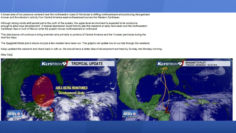
Friday's blog said: A broad area of low pressure centered near the northeastern coast of Honduras is drifting northwestward and producing disorganized shower and thunderstorm activity from Central America east-northeastward across the Western Caribbean.
Although strong winds aloft persist just to the north of the system, the upper-level environment is expected to be conducive enough to allow slow development. A tropical depression could form by late this weekend or early next week over the northwestern Caribbean Sea or Gulf of Mexico while the system moves northwestward to northward.
This disturbance will continue to bring torrential rains primarily to portions of Central America and the Yucatan peninsula during the next few days.
The Spaghetti Model plot is shown but just a few models have been run. This graphic will update live on our site through the weekend.
Keep updated this weekend and check back in with us. We should have a better idea of development and track by Sunday into Monday morning.
Josh Linker posted this story Saturday morning.
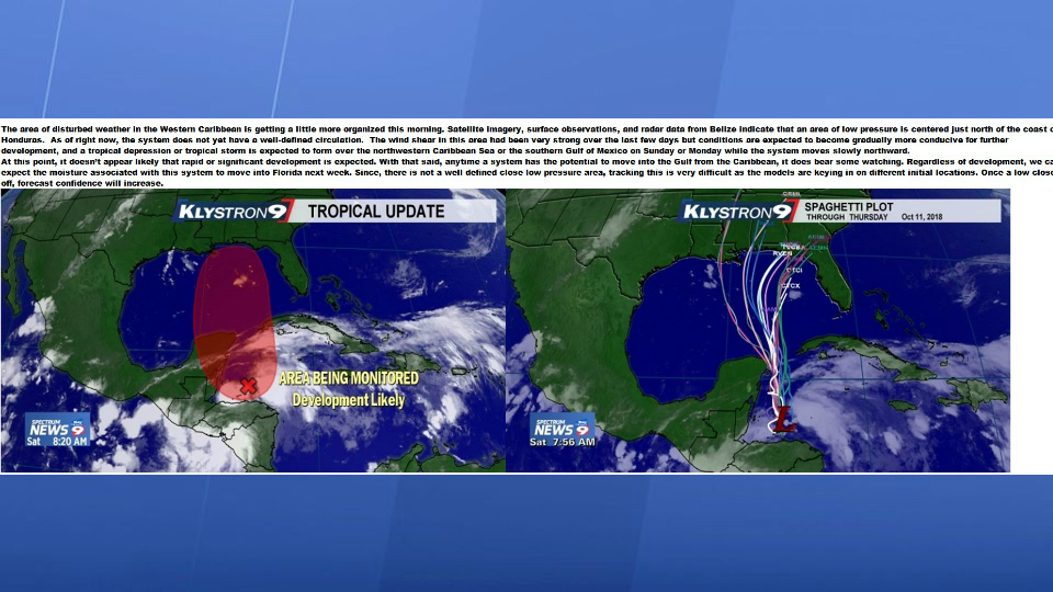
Saturday morning's post said: The area of disturbed weather in the Western Caribbean is getting a little more organized this morning. Satellite imagery, surface observations, and radar data from Belize indicate that an area of low pressure is centered just north of the coast of Honduras. As of right now, the system does not yet have a well-defined circulation.
The wind shear in this area had been very strong over the last few days but conditions are expected to become gradually more conducive for further development, and a tropical depression or tropical storm is expected to form over the northwestern Caribbean Sea or the southern Gulf of Mexico on Sunday or Monday while the system moves slowly northward.
At this point, it doesn’t appear likely that rapid or significant development is expected. With that said, anytime a system has the potential to move into the Gulf from the Caribbean, it does bear some watching. Regardless of development, we can expect the moisture associated with this system to move into Florida next week. Since, there is not a well defined close low pressure area, tracking this is very difficult as the models are keying in on different initial locations. Once a low closes off, forecast confidence will increase.
And this story was posted on our website Sunday morning.
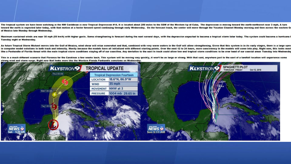
Here is what Sunday morning's story said: "The tropical system we have been watching in the NW Caribbean is now Tropical Depression #14. It is located about 250 miles to the SSW of the Western tip of Cuba. The depression is moving toward the north-northwest near 3 mph. A turn toward the north is expected later today, with that motion at a faster forward speed continuing through early Wednesday. On the forecast track, the center will move through the Yucatan Channel Monday morning and then across the eastern Gulf of Mexico late Monday through Wednesday.
Maximum sustained winds are near 35 mph (55 km/h) with higher gusts. Some strengthening is forecast during the next several days, with the depression expected to become a tropical storm later today. The system could become a hurricane by Tuesday night or Wednesday.
As future Tropical Storm Michael moves into the Gulf of Mexico, wind shear will relax somewhat and that, combined with very warm waters in the Gulf will allow strengthening. Given that this system is in its early stages, there is a large spread in computer model solutions in both track and intensity. Mostly because the models have all initialized with different starting points. Over the next 12 to 24 hours, more consistency in the models will come into play. Right now, this looks mostly like a Panhandle of Florida threat with the main tropical storm conditions staying off of our coastline. Any deviation to the east in track could allow low end tropical storm conditions to be over head of our coastal areas Tuesday into Wednesday.
This is a much different scenario that Florence for the Carolinas a few weeks back. This system will be moving very quickly, it won’t be as large or strong. With that said, anywhere just to the east of a landfall location will experience some strong wind and storm surge. Right now that looks more like the Western Florida Panhandle sometime on Wednesday.