


ST. PETERSBURG, Fla. — You may have seen the above graphic around social media over the weekend.
This is an outlook that is put out by the National Hurricane Center four times a day, every day, during hurricane season. The text on the graphic is what I added for explanation context.
It is something that has been a product of the NHC for a very long time. Now, with greater graphics abilities of TV stations or even just folks at home, it has become something that is easily shared through social media.
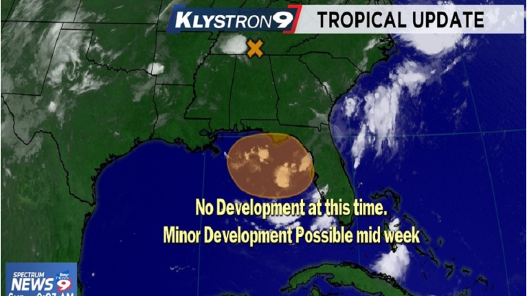
This outlook discusses the statistical probability that a tropical cyclone could develop over various time frames, the next 48 hours, and then 3 to 5 days out. First, it is important to understand that a tropical cyclone in this context does not necessarily mean a hurricane, or even a tropical storm. It simply means a low pressure area that has tropical, or warm core, characteristics.
In this case, we are tracking a non tropical, upper level feature over Tennessee that will be moving southward over the next few days. By Tuesday, as it moves southward with a frontal trough, a surface low pressure area may form in Georgia or the Florida Panhandle. After that, it could make its way into the Northeastern Gulf of Mexico.
Once in the Gulf, it looks like if anything is there it would drift west or west northwestward later next week.
Here are the takeaways...
First, since last week, our weather forecast for this upcoming week has been for increasing rain chances due to the frontal trough I mentioned pulling deeper moisture into Florida from the southwest, so for your planning purposes, nothing has changed.
Second, in this case, the chance for "tropical cyclone" development in the 3 to 5 day time frame is moderate. Remember, that that can sometimes just mean a warm core low pressure area in the tropics.
Third, should a tropical cyclone develop in the Gulf, it appears very unlikely that any kind of significant develop in the short term after development would be expected. In other words, this doesn't appear to be too big a deal.
Finally, it is important to remember that when you see images like this on social media, you should always check with a trusted source for more information as something like this is way too complicated to explain and address in a tweet and communicating possibilities and uncertainties and possible impacts or effects is our job here in the Spectrum Bay News 9 Weather Center.
So, I encourage you to go about your day...just make sure to have your umbrella as higher rain chances are in the forecast.