


You know we are in the heart of hurricane season when you see a cone (or two or three) on the weather map.
- WEATHER BLOG: The 9 Myths of Tropics and Preparation
- RELATED: Track the Tropics on Spectrum Bay News 9
- RELATED: Storm Season 2019
- More Spectrum Bay News 9 Weather Blogs
While the cone may appear to be a direct forecast, it's more complicated than that.
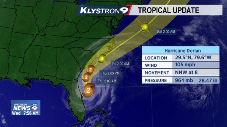
With Dorian in the Caribbean Wednesday morning and the cone showing it could move toward Florida over the holiday weekend, we've had a lot of questions about what the cone means.
Inside the cone is the forecast line that represents the probable track of the center of a tropical cyclone (a hurricane, tropical storm or tropical depression) over time increments in a set of circles going out to five days.
The size of the cone is based on the historical official forecast errors over five years.
What this means is that the size of the cone does not change. We could have a high confidence forecast or a low confidence forecast and the size of the cone won't change.
That means the average error for day 5 of the cone is around 200 miles!
That's why we say not to focus on the center of the cone but to pay attention to the entire cone.
Impacts can be felt outside the cone, of course, but every tropical storm and hurricane is different.
The cone is updated four times a day at 5 a.m., 11 a.m., 5 p.m. and 11 p.m. for each system in the tropics.
Based on forecasts over the last 5 years, the entire track of the tropical cyclone remains within the cone 60 percent to 70 percent of the time.
That also means there is about a 30 percent probability or higher that the center of the storm could go outside of the cone.
Sometimes the cone will shift based on new model guidance, hurricane hunter reports, and other weather observations.
That’s why it’s important to check in with us daily for our tropical update or more often if there is a tropical threat to the area.
Find out more information on Dorian and how to prepare for hurricane season at https://www.baynews9.com/fl/tampa/weather/hurricane-center

This graphic updates four times a day.