


TAMPA, Fla. — Almost 10,000 Lakeland Electric customers remain without power early Saturday morning due to damage caused by a tornado which first touched down at Lakeland-Linder Airport and traveled north across I-4 and into Kathleen in Polk County.
- RELATED: WEATHER: Bay Area Closures And Cancellations | Power Outage Map
- Potential Tropical Cyclone 16 strengthens to Tropical Storm Nestor
- Storm surge warnings, flood advisories up for parts of Bay area
- STORM SEASON 2019: Tropical Maps | Interactive Storm Tracker | Printable Supply Checklist | Tropical Storm 2019 Names
- JUMP TO: ▼ Live updates from our reporters in the field ▼
- WATCH US LIVE: Spectrum video customers — download the Spectrum TV app from the App Store or Google Play. If you're not a video customer, Spectrum Bay News 9 is providing free temporary access at baynews9.com/watchlive. You can watch the channel live on your desktop or laptop.
UPDATE — Severe Thunderstorm Warning for Sarasota Co. ended at 4:45 a.m.
2:02 a.m.: Tornado Watch issued for Citrus, Hernando, Hillsborough, Manatee, Pasco, Pinellas, Polk counties until noon Saturday.
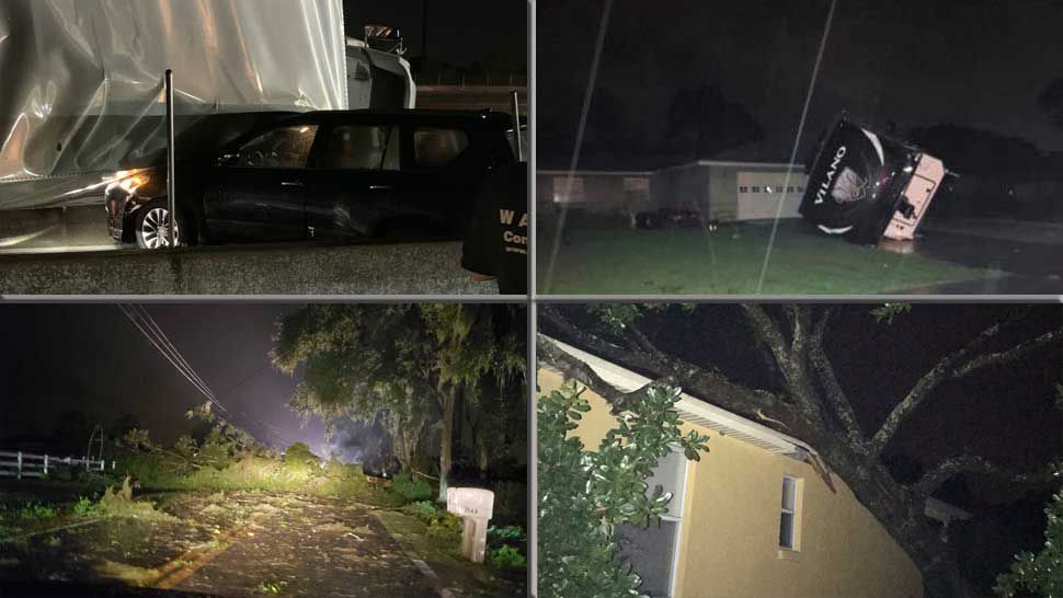
1:09 a.m.: Viewer Shelly Eddins sent us a photo of damage done to Kathleen Middle School in Kathleen. The school's roof was partially destroyed.
12:29 a.m.: Lakeland Electric is reporting almost 10,000 customers without power due to 46 outages in its service area. Click here to view their outage map.
12:10 a.m.: The tornado warning for Northwestern Polk County has been allowed to expire.
11:53 p.m.: Tornado warning for Northwestern Polk County until 12:15 p.m.
A severe thunderstorm capable of producing a tornado was located north of Lakeland, 13 miles northwest of Auburndale, moving at 25 miles per hour.
11:42 p.m.: The tornado warning for Southeastern Pasco, Northeastern Hillsborough, Northwestern Polk County has been allowed to expire.
11:38 p.m.: A tractor trailer overturned on I-4 westbound at Polk Parkway as the tornado crossed the roadway.
11:21 p.m.: A tornado was confirmed on the ground at Lakeland-Linder Airport.
10:57 p.m.: Tornado warning EXTENDED for Southeastern Pasco, Northeastern Hillsborough, Northwestern Polk County until 11:45 p.m.
At 10:55 p.m. a severe thunderstorm capable of producing a tornado was located near Lakeland Linder Airport, or near Plant City, moving north at 25 miles per hour.
Locations impacted include:
Lakeland, Plant City, Zephyrhills, Lakeland Linder Airport, Zephyrhills West, Medulla, Zephyrhills South, Zephyrhills North, Zephyrhills Municipal Airport, Gibsonia, Plant City Airport, Winston, Crystal Springs, Willow Oak and Kathleen.
10:29 p.m.: Tornado warning in effect until 11 p.m. for Eastern Hillsborough, Polk County
A tornado warning has been issued for eastern Hillsborough and west central Polk counties.
At 10:23 p.m. a severe thunderstorm capable of producing a tornado was located seven miles southeast of Fish Hawk, moving north at 25 miles per hour.
10:09 p.m.: Duke Energy is reporting just over 1,300 customers without power, many in the Seminole area of Pinellas County.
The company estimates restoration of power for those customers around 3:15 a.m.
9:55 p.m.: Flood advisory in effect until 11:15 p.m. for west central Pinellas County.
A flood advisory has been issued for west central Pinellas County until 11:15 p.m.
At 9:47 p.m. radar indicated heavy rain due to thunderstorms. This will cause minor flooding in the advisory area. Two to three inches of rain have already fallen. An additional one to two inches are possible.
Some locations that will experience flooding include:
Clearwater, Largo, Seminole, Harbor Bluffs, Ridgecrest, Safety Harbor, Belleair, Redington Shores, Belleair Bluffs, Belleair Beach, Redington Beach, Indian Shores, North Redington Beach, Belleair Shore, Walsingham Park and Belleair Shores.
9:40 p.m.: The Tornado warning was allowed to expire.
9:07 p.m.: Tornado warning in effect until 9:45 p.m. for Pinellas County.
A tornado warning has been issued for west central Pinellas County until 9:45 p.m.
At 9:02 p.m. a severe thunderstorm capable of producing a tornado was located seven miles southwest of Bay Pines, or eight miles southwest of Seminole, moving northeast at 15 miles per hour.
The dangerous storm will be near ...
- Redington Beach around 9:25 p.m.
- Bay Pines around 9:30 p.m.
- Seminole around 9:35 p.m.
- Clearwater, Largo, Pinellas Park, Ridgecrest, Harbor Bluffs and West and East Lealman around 9:45 p.m.
Nestor became the 16th named storm of the 2019 Atlantic storm season on Friday afternoon.
The center of the storm is located about 85 miles southwest of Apalachicola, Florida and about 95 miles south-southwest of Panama City.
Winds remained at 60 mph as of 11 p.m.

Nestor is moving quickly to the northeast at 20 mph.
In the Bay area, there will be a risk of isolated tornadoes overnight and into Saturday morning.
Nestor is poorly organized, so don't focus on center of the storm — most of the significant weather is well east of the center.
A storm surge warning is in effect for Citrus, Hernando, Pasco, and Pinellas counties. There's a coastal flood advisory in effect for Hillsborough and Manatee counties.
Wind advisories are up for inland Citrus, Hernando, and Pasco counties from 5 a.m. to 5 p.m. Saturday. Expect winds from the south from 20 to 30 mph, with gusts up to 40 mph. Gusty winds could blow around unsecured objects. Tree limbs could be blown down, and a few power outages may result.
A tropical storm warning is in effect for
- Navarre, Florida to Yankeetown, Florida
A storm surge warning is in effect for
- Indian Pass, Florida to Clearwater Beach, Florida
Live Updates from Reporters
In Citrus County, business owners did what they could to get ready for possible storm surge. Amber Lynd, who works at Peck’s Old Port Cove on North Ozello Trail, stopped by one of the self-serve sandbag stations set up by the county to help protect the restaurant.
Meanwhile, Douglas Lyles, who works at MacRae's of Homosassa, said preparations there included dealing with the effects of recent high tides.
“Right now, we’re just keeping down the water level. We picked everything up off the floor. We make sure that the parking lot’s clear and there’s no debris. Basically, keep people from getting hurt,” Lyles said.
Parts of Citrus County could see 3 to 5 feet of storm surge.
— Reporter Sarah Blazonis

- TRACK THE TROPICS: Watches, warnings, forecasts, satellite loops, spaghetti models
- 7-DAY FORECAST: Rain chances, county-by-county temperatures
- NEIGHBORHOOD RADARS: County-by-county radar images
- GET WEATHER ALERTS: Sign up to get Spectrum Bay News 9 real-time weather text alerts on your mobile device
- THEME PARK INCLEMENT WEATHER POLICIES: Major Florida theme parks' hurricane or inclement weather policies in case of cancellations, closures