


TAMPA, Fla. -- At first glance this might seem like a silly question. Afterall we have tons of automation built into the meteorology field in 2020. So how could the virus really impact weather forecasting?
The good news is that most meteorologists can work remotely in many cases. The other good news is that a lot of the instrumentation we’ve set up the past 50 years has gotten reliably automated such as satellites, sensors, buoys, etc.
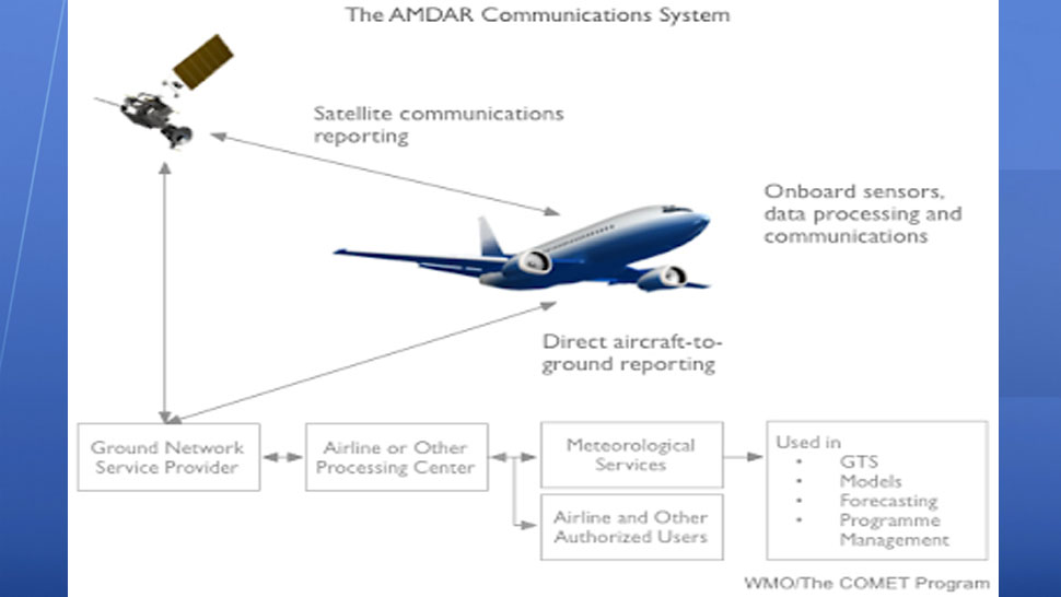
But what you might not know is that a lot of weather data comes from commuter planes. A program called AMDAR (Aircraft Meteorological Data Relay) transmits weather data from planes. This program typically produces 700,000 observations per day around the world. This data consists of temperature, wind, and water vapor measurements that then get transmitted into our weather computer models, which in turn we use to predict the weather. With the massive reduction in flights around the world, we’re now seeing about an 80 percent reduction in weather data from those planes.
A 2017 study published by the American Meteorological Society discovered that utilizing aircraft observations reduced six-hour computer forecast errors in wind, humidity, and temperature by 15% to 30% across the U.S. In other words, the more data we receive, the better our modeling gets, and therefore the better are forecasts can be.
The two most used weather models in the world, the American (GFS) and the European (ECMWF) utilize this data and could therefore see some impact. Exactly how much is still to be seen.
Keep in mind that it’s not all bad news, we still have the best satellite data we’ve ever had with the recent launch of GOES-16 and GOES-17 weather satellites. We also are still releasing weather balloons with radiosonde data twice a day all around the country. Susan Buchanan from NOAA (National Oceanic and Atmospheric Administration) reported, “Even though a decrease in this critical data will likely negatively impact forecast model skill, it does not necessarily translate into a reduction in forecast accuracy."
I agree on this assessment, especially within the United States because we’re lucky to have numerous tools and the largest group of meteorologists in the world that have a tremendous amount of knowledge in local weather. For example, here at Bay News 9 we notice when computer models aren’t doing a good job and counteract this by using our local knowledge of the Tampa Bay region to provide a more accurate forecast. Afterall, that’s our job. Computers might be able to fully comprehend the atmosphere 100 years from now, but at this point, humans still do a good job ‘fixing’ what the computers can’t fully understand.
The bigger issue from a global scale is that not all countries have these great tools. In some under-developed countries they can’t afford to release balloon data or install numerous weather sensors.
Therefore there will be gaps in weather data which could have an impact on our weather models. Remember that weather is constantly in motion around the entire globe, so although we might have more data in North America, if we have missing data in other areas of the world it will ultimately have an impact on our computer model accuracy here locally.
“At short range, most impact is on jet level winds and temperatures, partly because many of the aircraft reports are at this level, but also because this is an active part of the atmosphere,” ECMWF scientist Bruce Ingleby said.
In other words, the biggest impact will likely be noticed by the computer models in the jet stream level data about 30,000 feet high in the sky. In personal experience this usually leads to some error in timing and broad scale features in the atmosphere, especially beyond 4 days. But within a few days out this usually isn’t as big of a factor because we have satellite and radar data to fill the void.
Ironically, just last year a test was run without AMDAR data to simulate this exact scenario and the data was similar to what we’re discussing here. There was some reduction in the quality of data, mainly in the northern hemisphere for high altitude temperatures and wind. Research from the past decade has shown that the biggest impact might ultimately be to high-resolution short term models that help us within 36 hours of an event. We use these high-res models at Bay News 9 and will keep an eye on any inconsistencies that might arise.
All this being said, we’ll continue to offer very accurate forecasts, but there will be some bumps along the way and we won’t know for sure what the reduction in accuracy will be until possibly a month or two down the road. It’s only been a couple weeks and within our weather center we think we might have noticed a few small differences this week in some of the large-scale data but it wasn’t anything we couldn’t adjust to. Again, local knowledge plays a very big role in forecasting and we understand the Tampa Bay climate and what to expect with local patterns.