


When Hurricane Ian made landfall in Southwest Florida as Brian McClure and I were on the air that Wednesday afternoon, we saw a rare radar phenomenon in the eye of the hurricane.
What You Need To Know
- Radar saw debris with Hurricane Ian after landfall
- New technology allows us to see things inside storms we never could before
- Bay News 9 was one of the first in the world to have this technology
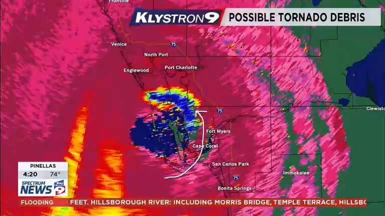
The Dual-Pol radar data showed a tremendous amount of debris being lofted as the powerful eyewall winds did their damage. The debris field was extensive, about 10 miles wide, and rotated around the eye in a counter-clockwise motion.
A little background, in 2009, Klystron9 debuted as one of the first five Dual-Pol radars owned by a TV station. A few years later, the National Weather Service upgraded all of their radars to Dual-Polarization using the same technology developed for the TV station radars.
When a weather radar is running Dual-Polarization, it sends vertical and horizontal pulses, hundreds of times a second. The radar can measure the difference in the return of these pulses and determine the size and shape of raindrops or hail.
A Dual-Pol radar can judge if the returns are coming from raindrops, which are usually about the same size and shape, or from other objects such as birds or smoke. One of the unexpected advantages of Dual-Pol weather radars is the detection of debris being lofted.
This was first noticed by tornadoes touching down. The radar can now give us a firm signature when the tornado touches down and starts causing damage. This leads to more confidence when tornado warnings are issued.
We’ve had several tornadoes in our area the last couple of years that showed debris on the radar within a moment of the first touchdown.
As Ian was approaching the coast, our radar manufacturer, Baron Weather contacted us. I got a tip to look for debris in the eyewall as the Category 4 hurricane came ashore.
I didn’t think much of it. I had never heard of a radar detecting debris from a hurricane landfall. As Ian hit the Fort Myers area, I switched to look at the debris detection product and there it was! Our banner at the top said '“Possible Tornado Debris,” which was incorrect as this was debris from a hurricane.
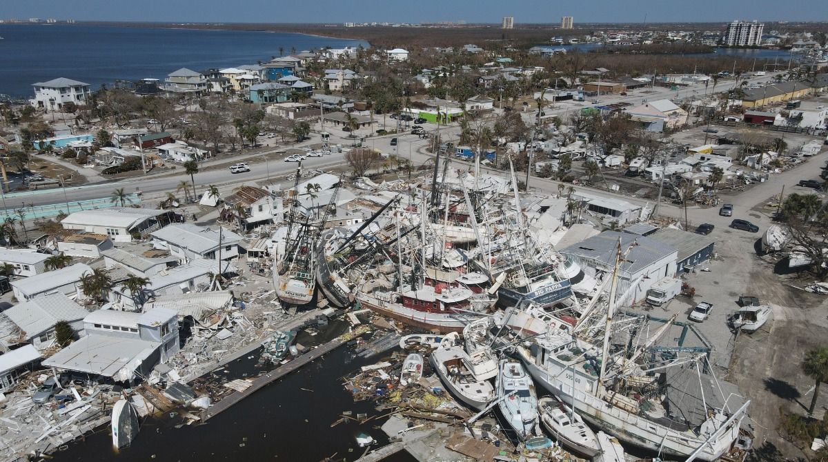
The debris signature was huge, and we sadly knew immediately what this meant. It wasn’t cool or exciting; it was people’s lives and homes and businesses being destroyed and lifted by the hurricane winds.
As we watched in awe the debris, about 10 miles wide, swirled inside the eye but eventually disappeared as the debris either fell to the ground or the hurricane eyewall weakened enough as it moved inland to no longer be causing that much wind damage to the east.
Afterward, several of our viewers contacted us, saying they had never seen such technology at work. We like to push the boundaries and use our technology to give you the best information possible.
Just like our Qrisq Storm Surge product was forecasting NO storm surge for Tampa Bay the previous day, we work with terrific vendors and scientists to bring you the best severe weather coverage.
Our team of meteorologists dives deep into the science of weather and breaks down timely weather data and information. To view more weather and climate stories, check out our weather blogs section.