


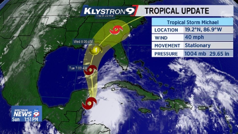
ST. PETERSBURG, Fla. — The disturbance in the Caribbean is now Tropical Storm Michael and is moving to the north at 5 mph with winds at 40 mph.
- System now Tropical Storm Michael
- Storm moving toward the Gulf
- TRACKING THE TROPICS: Watches, warnings, forecasts, spaghetti models
- Watch our Tropics updates each hour at :49
A turn toward the north is expected later today, with that motion at a faster forward speed continuing through early Wednesday. On the forecast track, the center will move through the Yucatan Channel Monday morning and then across the eastern Gulf of Mexico late Monday through Wednesday.
Some strengthening is forecast during the next several days. The system could become a hurricane by Tuesday night or Wednesday.
As Tropical Storm Michael moves into the Gulf of Mexico, wind shear will relax somewhat and that, combined with very warm waters in the Gulf, will allow strengthening.
Given that this system is in its early stages, there is a large spread in computer model solutions in both track and intensity. Mostly because the models have all initialized with different starting points. Over the next 12 to 24 hours, more consistency in the models will come into play.
Right now, this looks mostly like a Panhandle of Florida threat with the main tropical storm conditions staying off of our coastline. Any deviation to the east in track could allow low end tropical storm conditions to be over head of our coastal areas Tuesday into Wednesday.
This is a much different scenario than Florence for the Carolinas a few weeks back. This system will be moving very quickly, it won’t be as large or strong.
With that said, anywhere just to the east of a landfall location will experience some strong wind and storm surge. Right now that looks more like the Western Florida Panhandle sometime on Wednesday.

