


TAMPA, Fla. — 5 p.m. update: Ian has status as a hurricane. More updates come.
PREVIOUS
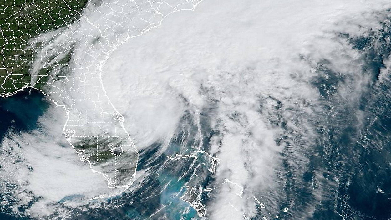
Tropical Storm Ian's center is back offshore with estimated winds back up to 70 mph.
It is forecasted to barely rise back to hurricane status before the South Carolina landfall tomorrow. Tropical Storm Warnings have been extended farther up the North Carolina coast.
What You Need To Know
- Check Klystron Radar
- Watch live storm coverage
- LIVE UPDATES: Follow reports, photos, videos from our Spectrum News 9 reporters in the field
- Sign up for Spectrum News app weather alerts
- Submit your weather photos
- Visit our Storm Season section
- Power outage map
- Shelters
- Closings
- Hurricane supply checklist
Ian strengthened into a Category 4 hurricane early Wednesday morning and winds peaked at 155 mph before landfall.
The system weakened as it crossed through Central Florida, but is still causing strong wind gusts and heavy rain.
Ian is moving toward the northeast at 8 mph.

Ian will continue moving north-northeastward after making landfall in southwest Florida, and move back offshore into the Atlantic Thursday.
Now the main impacts for the Tampa Bay region will be as follows:
- Occasional rain
- Gusty winds
The good news is dry air will wrap around on the backside Friday setting us up for a dry, less humid weekend ahead.
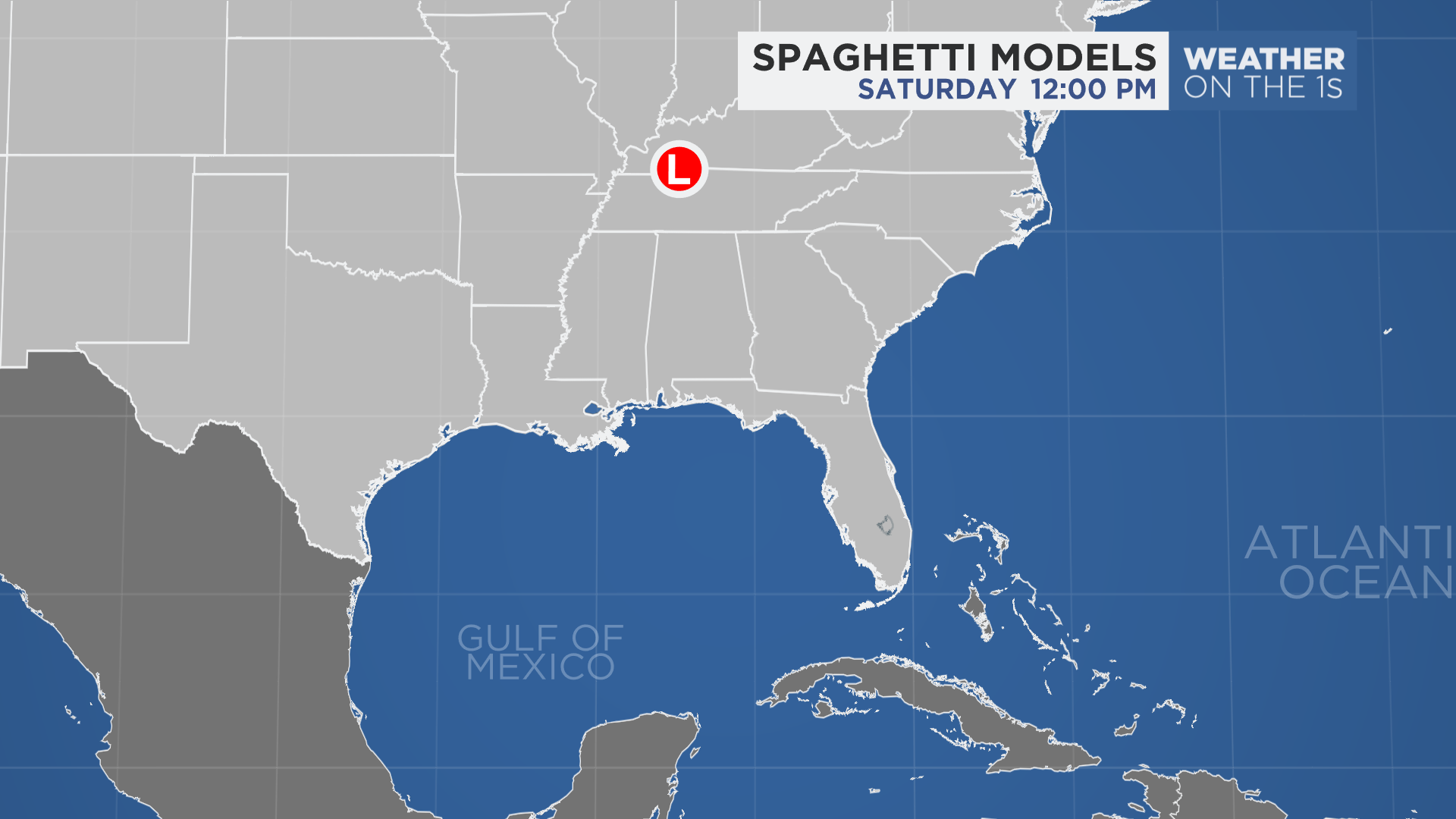
Spaghetti models or plots show a series of individual computer forecast models together on one map. They are useful to give insight into whether multiple models are in agreement on the path of the storm but they do not address the storm’s forecast intensity, winds, flooding and storm surge potential or other data. Tap here for more details on how to best use these models
River Flooding Warnings
Withlacoochee including US 301 Trilby, Croom, SR 200 Holder, US 41 Dunnellon - minor flooding is forecast
Hillsborough including Morris Bridge, Temple Terrace, Hillsborough River State Park - minor flooding is forecast
Cypress Creek including SR 54 Worthington Gardens - minor flooding is forecast
Alafia including Lithia, Riverview near US 301 - major flooding is forecast
Little Manatee including Wimauma at US 301 - major flooding is forecast
Manatee including Myakka Head at SR 64, Rye Bridge - major flooding is forecast
Myakka including Myakka River State Park - major flooding is forecast
Peace including Bartow, Zolfo Springs at SR 17, Arcadia at SR 70 - major flooding is forecast
Watches and Warnings
SUMMARY OF WATCHES AND WARNINGS IN EFFECT:
A Storm Surge Warning is in effect for...
* Middle of Longboat Key southward to Flamingo including Charlotte Harbor
* Flagler/Volusia Line to the mouth of the South Santee River
* St. Johns River
A Tropical Storm Warning is in effect for...
* North of Bonita Beach to Indian Pass Florida
* Boca Raton Florida to Cape Lookout North Carolina
* Lake Okeechobee
A Storm Surge Watch is in effect for...
* North of South Santee River to Little River Inlet
A Hurricane Watch is in effect for...
* Flagler/Volusia County Line to the South Santee River
A Storm Surge Warning means there is a danger of life-threatening inundation, from rising water moving inland from the coastline, in the indicated locations. For a depiction of areas at risk, please see the National Weather Service Storm Surge Watch/Warning Graphic, available at hurricanes.gov. This is a life-threatening situation. Persons located within these areas should take all necessary actions to protect life and property from rising water and the potential for other dangerous conditions. Promptly follow evacuation and other instructions from local officials.
A Hurricane Warning means that hurricane conditions are expected somewhere within the warning area. Preparations to protect life and property should be rushed to completion.
A Tropical Storm Warning means that tropical storm conditions are expected somewhere within the warning area.
A Storm Surge Watch means there is a possibility of life- threatening inundation, from rising water moving inland from the coastline, in the indicated locations during the next 48 hours.
For storm information specific to your area, please monitor products issued by your national meteorological service.
5:00 A.M. IAN COORDINATES
LOCATION...28.0N 80.9W
ABOUT 40 MI...70 KM SE OF ORLANDO FLORIDA
ABOUT 35 MI...55 KM SW OF CAPE CANAVERAL FLORIDA
MAXIMUM SUSTAINED WINDS...65 MPH...100 KM/H
PRESENT MOVEMENT...NE OR 40 DEGREES AT 8 MPH...13 KM/H
MINIMUM CENTRAL PRESSURE...986 MB...29.12 INCHES
WARNINGS vs. WATCHES: What do they mean?
A Hurricane Warning means that hurricane conditions are expected somewhere within the warning area, in this case within 24 to 36 hours. Preparationsto protect life and property should be rushed to completion.
A Tropical Storm Warning means that tropical storm conditions are expected somewhere within the warning area within 36 hours.
A Storm Surge Warning means there is a danger of life-threatening inundation, from rising water moving inland from the coastline, during the next 36 hours in the indicated locations. For a depiction of areas at risk, please see the National Weather Service Storm Surge Watch/Warning Graphic, available at hurricanes.gov. This is a life-threatening situation. Persons located within these areas should take all necessary actions to protect life and property from rising water and the potential for other dangerous conditions. Promptly follow evacuation and other instructions from local officials.
A Storm Surge Watch means there is a possibility of life threatening inundation, from rising water moving inland from the coastline, in the indicated locations during the next 48 hours. For a depiction of areas at risk, please see the National Weather Service Storm Surge Watch/Warning Graphic, available at hurricanes.gov.
A Hurricane Watch means that hurricane conditions are possible within the watch area. A watch is typically issued 48 hours before the anticipated first occurrence of tropical-storm-force winds, conditions that make outside preparations difficult or dangerous.
A Tropical Storm Watch means that tropical storm conditions are possible within the watch area, generally within 48 hours.