


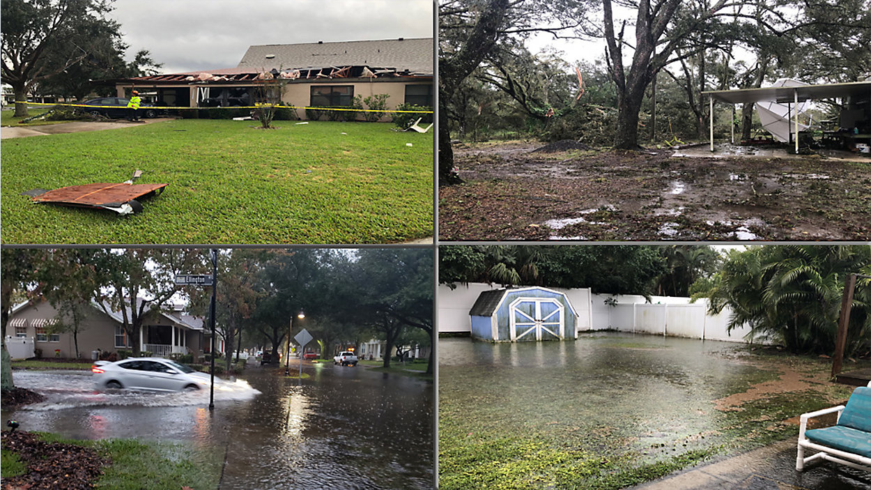
ST. PETERSBURG, Fla. — Parts of the Bay area are seeing damage after severe storms swept through the region on Thursday.
Areas that are seeing damage and flooding are Lake Wales, Zephyrhills, Myakka City, Palm Harbor, Bradenton, and Citrus County.
The storms prompted several tornado warnings and watches with the majority of the severe weather hitting Polk County.
The rain started in the Bay area Wednesday afternoon and continued on and off through Thursday. The heavy rain and storms hit early Thursday morning, covering the entire Bay News 9 coverage area.
The storms started to move into Central Florida around 12 - 1 p.m. on Thursday.
More rain is expected Friday as Bay area residents worry about flooding and damage cleanup.
- LIVE RADAR
- County Radars
- Sky 9 Cameras
- Power Outage Maps
- Cancellations
- LIVE Traffic Map
- ABOVE: Video of storm damge in Pasco County
- Stream LIVE ON SPECTRUM TV APP
TIME STAMPED UPDATES:
3:52 p.m. - From Chief Meteorologist Mike Clay: The tornado that touched down south of Lake Wales one mile west-southwest of Crooked Lake Park at 9:15 a.m. was an EF 0. Its path was 0.7 miles long and 30 yards wide.
In comparison, the Myakka City tornado, which touched down seven miles east of Lake Manatee State Park at approximately 8:30 a.m., was also rated EF 0. Its path was 0.2 miles long and 75 yards wide.
3:28 p.m. - Flood watch for Citrus, Hernando, Hillsborough, Manatee, Pasco and Pinellas remains in effect into early Friday morning.
Showers with a cold front will continue to move across the area through Friday morning. Additional rainfall amounts of up to 1 inch combined with saturated soils from heavy rainfall today and last week will keep a flooding threat across the region.
More rainfall will have the potential to cause flooding of low-lying and poor drainage areas. Flooding will also affect roadways, rivers, creeks, and smaller streams.
1:08 p.m. - Tornado Watches canceled for Pinellas, Hillsborough, Manatee counties.
1:05 p.m. - All 4 units in Lake Wales quadplex condemned due to heavy roof damage that left 1 resident injured at the Crooked Lake Park near Warner University.
12:37 p.m. - Nate's Animal Rescue on Lorraine Road flooded. Animal rescues taking place.
12:25 p.m. - Reports of damage at VA in Palm Harbor.
12 p.m. - Tornado Warning in eastern Manatee near Myakka City until about 12:30 p.m.
From Chief Meteoroligst Mike Clay: Clearwater Beach Pier reported a 55 mph wind gust. Lakeland Highlands had a peak gust of 48 mph.
11:55: a.m. - Traffic Alert: A tractor-trailer jackknifed on southbound I-75 after the southern Apex in Palmetto. Traffic moving along the left shoulder only.
11:45 a.m. - Flood Advisory for Pasco, Hernando, Manatee, Pinellas, Hillsborough, and Polk Counties until 1:15 p.m.
Some locations to experince flooding are:
Tampa, Spring Hill, Clearwater, Lakeland, Largo, North Port, Sarasota, Bradenton, Pinellas Park, Plant City, Winter Haven, Temple Terrace, Haines City, Bartow, Seminole, New Port Richey, Lake Wales, Auburndale, Zephyrhills, and Palmetto.
11:42 a.m. - Rainfall totals so far today: 6.25 inches Lutz, 4.5 Seminole, 4.2 inches in South Lakeland (3.2” in one hour!) according to Mike Clay
11:38 a.m. - Update from Pasco County: 70 homes in the community have various different levels of damage. Four of those 70 homes have been deemed unsafe to live in, and the residents of those homes are staying with friends.
Pasco County Fire Rescue and Pasco County Emergency Management have set up a command center in the Forest Lakes Estates community center.
11:15 a.m. - Tornado Warning for eastern Polk County near Lake Pierce until 11:45 a.m.
11:03 a.m. - 67 homes were damaged at the Forest Lake Estates Mobile Home community in Zephyrhills. Four homes are unlivable.
11 a.m. - Storm damage at the Forest Lake Estates Mobile Home community in Zephyrhills. Residents say all of a sudden they heard a lot of wind, and then a tree came crashing through their house.
10:50 a.m. - Hundreds of trees down in Myakka City after mother and daughter hide out in bathroom as tornado touches down near by.
10:40 a.m. - "I had just turned the lights on, and I heard this noise coming, and all of sudden my carport was gone. It was just that fast. I don't think it lasted more than 15-20 seconds," said Gilbert, a Pasco County resident.
10:13 a.m. - Confirmed tornado damage in Crooked Lake Park in Polk County. Home on Genesis Point Drive received roof damage. One person was injured.
9:58 a.m. - Polk added to flood advisory along with Pinellas, Pasco, Hillsborough, and Manatee Counties.
9:51 a.m. - Tornado Warning until 10:15 a.m. in eastern Polk County between Wauchula and Frostproof.
9:35 a.m. - Increasing numbers of power outages reported by TECO, Duke Energy. Check outages here
9:25 a.m. - Debris reported in Lake Wales area
9:23 a.m. - Tornado Warnings in Lake Wales area; watches in parts of Sarasota County.
9:20 a.m. - BN9 Chief Meteorologist Mike Clay: Looked back on Klystron and there was no tornado signature here but there was certainly high winds…. Radar had 50-60 mph straight line winds in the Z’hills area when the damage hit.
9:11 a.m. - Pasco County Fire Rescue on scene of a possible tornado touchdown in the 6400 block of Forest Lake Dr in Zephyrhills.
Officials say 20 or more homes with minor to moderate damage inside the Forest Lakes Estates Mobile home community. No injuries reported.
8:55 a.m. - Possible tornado touches down along U.S. 98 near Fort Meade in Polk County.
8:40 a.m. - Tornado warning has expired for Polk County.
8:35 a.m. - Areas in Polk Couny area seeing possible tornado activity. 9 miles south of Bartow area of concern right now. Residents should be paying attention.
ORIGINAL POST:
Two tornado warnings have been issued for parts of Polk County until 8:30 and 8:45 a.m.
Also a tornado watch has been issued until 4 p.m. for Polk, Hillsborough, Pinellas and Manatee counties.
A batch of very heavy storms is moving across the Bay area with some strong to severe storms possible.
- Flood Watch: Citrus, Hernando, Pasco, Hillsborough, Pinellas, Manatee Counties
- Flood Watch in effect from 1 a.m. Thursday through Friday morning
- Heavy thunderstorms
- Windy Friday-coastal flooding
- Weather Blog: Thursday, Friday Weather Hazards
Warm, unstable air will be pulled back northward as the low pressure to our west moves in our direction. That along with a strong southerly wind in front of the cold front will result in numerous thunderstorms.
There could be strong winds and an isolated tornado. That is something we will be watching and tracking carefully.
Temperatures will climb just a bit to near 70, but the clouds and rain will keep them from getting any higher.
- WEATHER ON THE GO: Download the Spectrum Bay News 9 app and get Klystron 9 alerts wherever you are.
- GET WEATHER ALERTS: Sign up to receive weather text alerts from Spectrum Bay News 9
- Klystron 9 | 7-Day forecast | Tampa Bay-area temperatures | Travel weather
The bulk of the heavy rains will move out this evening, but there will still be a few lingering showers at that time.
Otherwise tonight will be mostly cloudy with lows in the low 60s.
Friday will feature a huge blast of cooler air from the west as the low pressure passes to our north. That will result in a rush of winds off the gulf, so expect high surf, coastal flooding, and beach erosion that day. Rain showers will come through the area, making for another wet day. Southwest to west winds will be very strong all day, so a Coastal Flood Warning will be in effect.
Temperatures will not climb at all that day and winds will be strong from the west at 20 to 40 mph.
- Flood watch for coastal counties including Hillsborough due to heavy rain and high rainfall totals
- Gale warning for gulf waters through Friday
- Coastal flood warning starting this evening through Friday
- High surf advisory and threat for severe storms this morning into early afternoon
Finally drier air will start moving in Saturday, but it will come with cool conditions.
Saturday will clear out with highs only in the upper 50s to near 60.
Saturday night will be clear and cold with lows in the 30s and 40s.
Sunday will be mostly sunny with highs in the mid 60s.
Sunday night will be mostly clear and cold with lows in the 30s and 40s again.
Monday will start a moderating trend with highs in the upper 60s to near 70 under partly cloudy skies.
Tuesday for Christmas will be partly cloudy and milder with highs in the low 70s.
7-day forecast

We want your pictures!
Show us what the weather looks like in your neighborhood. Your photo could end up on Spectrum Bay News 9.
- Get the Spectrum Bay News 9 app for iOS or Android
- Tap "Submit Content" at the bottom of the app menu
- Remember to include your name and location