


ST. PETERSBURG, Fla. — Skies will go mostly clear overnight into early Tuesday morning with drier, less humid air moving into the region behind this latest front on a northerly breeze.
- Storm damage in Citrus County
- Front will bring showers, gusty winds, potentially strong storms
- SEE BELOW: See our 7-day forecast ▼
Tuesday morning will start out cooler and comfortable with lows in the 60's, and 50's for parts of Citrus and Hernando County.
Tuesday will be a mostly sunny day, so although the humidity will be much lower, the afternoon highs will still make it into the mid 80's.
Tuesday night will be pleasantly cool with lows in the 50's and 60's.
- WEATHER ON THE GO: Download the Spectrum Bay News 9 app and get Klystron 9 alerts wherever you are
- GET WEATHER ALERTS: Sign up to receive weather text alerts from Spectrum Bay News 9
- Klystron 9 | 7-Day forecast | Tampa Bay-area temperatures | Travel weather
Wednesday will be mostly sunny with continued low humidity. With the time of year and sun angle, expect the afternoon highs to reach the upper 80's.
Winds will shift and come from the south on Thursday, which will bring the humidity back up and start bringing clouds and some rain chances back to the region.
The chance of a shower on Thursday will be about 20 percent. Then the coverage will increase on Friday to about 50 percent and stay there into Saturday.
High temperatures during that time will be in the mid to upper 80's.
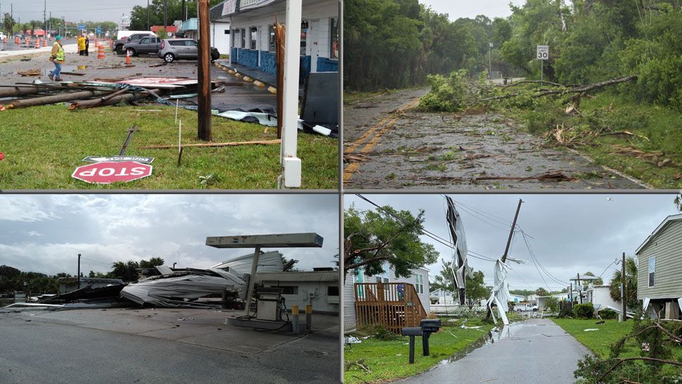
EF-0 Tornado damages homes in Citrus County
Storms, including some that have been strong to severe with damaging wind, moving across the Bay area region early Monday afternoon. An EF-0 tornado has been confirmed in Homosassa. Several structures were damaged.
At 9:39 am, a waterspout moved onshore the coast of Homosassa as a tornado, which continued on an easterly path, before lifting in Homosassa Springs at 9:48am.
There was a narrow path of damage, which started across a mobile home park near Buzzard Point. It produced minor damage to seven structures and major damage to two structures. Numerous trees were downed or snapped in the Homosassa Springs Wildlife Park. Other damage reports from the tornado include a downed billboard and the sail of a gas station that blew off.
Here are the totals of rainfall the region received thanks to today's storms:
MANATEE
- Bradenton 1.83
- Parrish 1.33
- Lakewood Ranch 1.23
- Palmetto 1.21
- Sarasota/Bradenton Airport 0.83
PINELLAS
- Largo 1.19
- St. Pete/Clearwater Airport 0.80
- Crystal Beach 0.75
- Clearwater 0.23
- St. Petersburg 0.02
HILLSBOROUGH
- Odessa 1.37
- Brandon 1.29
- Downtown Tampa 1.25
- Lutz 0.97
- Plant City 0.63
- Riverview 0.56
- Tampa Airport 0.51
- USF 0.49
POLK
- Kathleen 0.98
- Lakeland 0.75
- Davenport 0.75
- Lakeland Highlands 0.56
- Citrus Ridge 0.40
- Winter Haven 0.29
PASCO
- Land O’ Lakes 0.78
- New Port Richey 0.70
- Zephyrhills 0.28
HERNANDO
- Brooksville 0.01
CITRUS
- Sugarmill Woods 1.33
- Floral City 0.96
- Inverness 0.35
- Crystal River 0.23
Following the front, drier, more comfortable air will move in for the next couple of days. Highs will be in the mid 80s Tuesday and Wednesday with mornings in the 60s.
The weather will become unsettled again to end the week.
7-day forecast
