


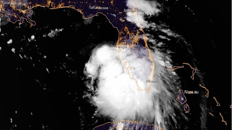
TAMPA, Fla. — Tropical Storm Sally is getting better organized off of the southwest Coast of Florida. It is moving away from the peninsula, so wind over land will not be a threat.
With saturated ground of recent days, there is the potential for flooding, so a flood watch continues through Monday.
Sally will be moving over the warm Gulf waters and will strengthen over the next two days before making a landfall sometime late Monday night or very early Tuesday morning near southeast Louisiana.
It will likely be a hurricane at that time and some indications are that it could be a Category 2. The main threats will be hurricane-force wind and a storm surge concern east of the center. There is still some exact track uncertainty but southeast Louisiana seems to be the highest likelihood of a landfall.
Details as of 11 a.m.:
- LOCATION: 275N 84.9W
- ABOUT 135 MI W OF ST. PETERSBURG
- ABOUT 280 MI ESE OF THE MOUTH OF THE MISSISSIPPI RIVER
- MAXIMUM SUSTAINED WINDS: 60 MPH
- PRESENT MOVEMENT: WNW AT 12 MPH
- MINIMUM CENTRAL PRESSURE: 998 MB 29.48 INCHES
Watches and Warnings
The hurricane warning along the coast of Louisiana has been extended westward to Morgan City.
A tropical-storm warning has been issued for the coast of Louisiana, from west of Morgan City to Intracoastal City.
Summary of Watches and Warnings in Effect:
A storm-surge warning is in effect for:
- Port Fourchon Louisiana to the Mississippi/Alabama Border
- Lake Pontchartrain, Lake Maurepas, and Lake Borgne
A hurricane warning is in effect for:
- Morgan City Louisiana to Ocean Springs Mississippi
- Lake Pontchartrain and Lake Maurepas including metropolitan New Orleans
A storm-surge watch is in effect for:
- Mississippi/Alabama Border to the Alabama/Florida Border
A hurricane watch is in effect for:
- East of Ocean Springs to the Alabama/Florida Border
A tropical-storm warning is in effect for:
- East of Ocean Springs to Indian Pass
- Intracoastal City Louisiana to west of Morgan City
A tropical-storm watch is in effect for:
- Indian Pass to Ochlockonee River Florida
Elsewhere in the tropics, Hurricane Paulette will be impacting Bermuda and Tropical Depression 20 will likely become the next named tropical storm on Sunday but will remain out in the Atlantic Ocean.